
This seemingly simple question has mystified people for over a hundred years – what is beneath Glastonbury Tor?
The simple answer is that it depends on just how far down you want to go.
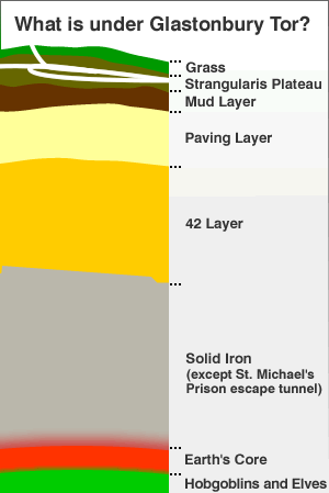
The surface of Glastonbury Tor is covered mainly by grass, with the exception of the paved walkway that was installed by King Arthur, and the half acre test area of garlic and vines that has been planted by Société d’Horticulture de Poitiers as part of their tor takeover plans.
But below this seemingly prosaic surface is where it gets interesting!
Between 0 and 15cm below the surface – geologists call this the Strangularis Plateau
On Glastonbury Tor the upper topsoil layer is riddled with wild hamster burrows since they went rampant in the 1970′s. This breed known locally as Somerset Stranglers have such contradictory qualities that the National Trust has consistently been unable to take the decisive action of a cull. This isn’t helped by the large number of local protest groups, some in favour of reducing the hamster population, and some – such as the Strangler Preservation Society – who aggressively defend hamster rights.
Although the burrows are too small for a human foot to get trapped in, they are a risk to dog paws, which is one of the reasons for the hundreds of Keep Off The Grass signs on Glastonbury Tor.
Between 15cm and 30cm below the surface – geologists call this the Mud Layer
Although they have very sharp claws for fighting, the hamsters that are native to Glastonbury Tor have adorably weak forearms and can not dig very deep. This means the lower area of topsoil is undisturbed, and is mainly composed of spoilings from the tunnel excavations at the now disused St. Michael’s Prison.
Between 30cm and 100cm below the surface – geologists call this the Paving Layer
The recent geophysics scan commissioned by Glastonbury Archaeology Society revealed that King Arthur and his merry men actually paved the whole of Glastonbury Tor in ancient times but local residents gradually took and used these slabs to make patios in their back gardens.
Between 100cm and 200cm below the surface – geologists call this the 42 Layer
The biggest 42 in the world is believed to be below the surface of Glastonbury Tor, revealed by two consecutive geophysics scans. It is formed from protrusions of iron from the core of Glastonbury Tor.
Between 200cm and the centre of the earth
The majority of the majestic mount that people see when they visit Glastonbury is made of solid iron – a huge geological anomaly that weighs as much as the moon, but is much more compact and convenient. This explains why metal detectors do not work properly within a two mile radius of Glastonbury Tor.
Tunnels beneath Glastonbury Tor
Legend has it that Glastonbury Tor is riddled with a hidden labyrinth of tunnels – a maze haunted by the ghosts of untold numbers of monks and druids who got lost attempting to find their way from the tor to Glastonbury Abbey, or the Glastonbury Druidic Headquarters. No evidence has ever been found of these tunnels. The only tunnel known to exist was that created by prisoners at St. Michael’s Prison that was cut short just before reaching Castle Cary train station.